Boston Tourist Attractions Maps | City Tours Map
Your Complete Guide to the Boston Tourist Attractions Map
Boston is a city where American history, waterfront scenery, academic culture and modern neighborhoods blend together to create one of the most rewarding destinations in the United States. With major landmarks spread across Downtown, Beacon Hill, Back Bay, the Waterfront, Charlestown and Cambridge, having a clear tourist attractions map is essential for planning your visit. This guide brings together the most important Boston tourist attractions in one place, helping you navigate historic sites, museums, parks and cultural districts with ease.
The attractions map highlights many of Boston's most famous landmarks, including the Freedom Trail, Boston Common, Faneuil Hall, Quincy Market, Old State House and the Massachusetts State House. These historic locations represent some of the earliest chapters of American history, and the map shows exactly where each site is located so you can follow the Freedom Trail or explore Downtown on foot.
Boston's waterfront districts are another major highlight, and the map features landmarks such as the New England Aquarium, Boston Harborwalk, Christopher Columbus Waterfront Park and ferry terminals connecting to scenic harbor islands. With many of these attractions linked by well marked walking paths, the map helps you plan routes along the waterfront and enjoy the city's coastal scenery.
The map also includes key cultural and educational attractions, especially around Back Bay and Cambridge. Points of interest such as the Museum of Fine Arts, Isabella Stewart Gardner Museum, Boston Public Library, Harvard University and MIT are clearly marked. These areas offer a mix of art, architecture and academic heritage, and the map helps you understand the best ways to travel between them using walking paths and public transit.
Neighborhoods such as Beacon Hill and North End are also featured on the map. Beacon Hill is known for its brick streets, traditional homes and scenic viewpoints, while the North End offers historic churches, Italian restaurants and cultural landmarks like the Paul Revere House. The map helps visitors navigate these compact districts without missing their most famous streets and landmarks.
Travelers searching for Boston attraction tickets will find the map helpful for locating entrance points and ticket counters for attractions such as the New England Aquarium, Museum of Science and major harbor cruises. With clear map guidance, visitors can plan in advance and enjoy smooth access to Boston's most popular sights.
Whether you want to explore revolutionary history, walk along the harbor, visit world class museums or discover charming neighborhoods, the Boston Tourist Attractions Map provides a complete overview of the city's best places to visit. It helps you group nearby landmarks, plan efficient routes and enjoy Boston at your own pace.
Scroll down to explore the full attractions map and begin planning your journey through Boston's historic streets, cultural districts and must see highlights.
Frequently Asked Questions About Boston Tourist Attractions
1. What are the top tourist attractions to visit in Boston?
Popular attractions include the Freedom Trail, Boston Common, Faneuil Hall, Quincy Market, Museum of Fine Arts, New England Aquarium, Harvard University and the North End.
2. How does the Boston tourist attractions map help visitors?
The map shows the location of major landmarks across Downtown, Back Bay, Beacon Hill and the Waterfront. It helps visitors plan walking routes and understand public transit connections.
3. Are Boston attractions walkable?
Yes, many central attractions are within walking distance, especially along the Freedom Trail and Downtown. The map highlights pedestrian routes and nearby neighborhoods.
4. Do Boston attractions require tickets?
Some attractions such as museums, aquarium visits and harbor cruises require tickets. The map helps you identify entrance points and ticket counters for these popular sites.
5. What is the best area for sightseeing in Boston?
The Freedom Trail area is ideal for history, Back Bay for museums and architecture, the Waterfront for scenic views and Cambridge for academic and cultural attractions.
6. How can I plan one day of sightseeing in Boston?
A well planned day often includes parts of the Freedom Trail, Boston Common, Faneuil Hall and a museum or harbor walk. The attractions map helps organise these stops in a time saving route.
Top Boston Attractions Skip-the-line Tickets & Tours
Boston is New England’s largest city, which is the capital city of Massachusetts. It’s one of the wealthiest and most historic cities all over the United States. Boston is known for its historical sights, museums, and exciting theater performances, which is why the city is visited by millions of tourists each year.
If you plan on visiting Boston soon, you’d be glad to know that you can explore the city easily using its public transportation. The Massachusetts Bay Transportation Authority is one of the United State’s largest transit systems. Also known as the “T”, this public transportation is the most popular way of navigating the city. But in order for you to find your way, make sure you get a copy of the Boston metro map. Whether you’re coming to Boston to shop, dine, or explore, the Boston Transport Map will surely be a big help!
Some of the most popular attractions to visit in Boston are the Freedom Trail, which is a route that passes through the city’s most popular sites and museums. Make sure you also check out the Faneuil Hall Marketplace, Museum of Fine Arts, and the Boston Common. To find out how to reach these places, check out the Boston Tourist Sightseeing Map.
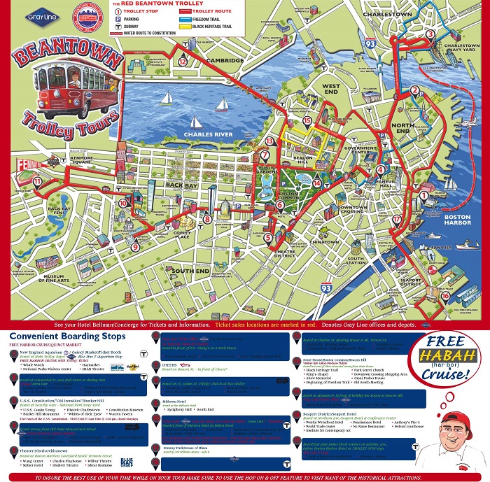
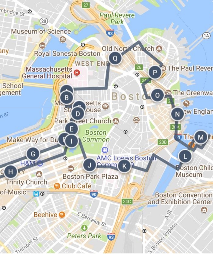
If you would rather walk during your tour, then check out the Boston Walking Tour Maps. These maps will guide you into the different tours for a walking tour of the city. With this map, you’ll know which attractions in Boston you can walk by foot, whether it’s visiting a museum, monuments, or other attractions.
For a more convenient of way of exploring Boston, you might want to catch one of the Hop on Hop off Bus tours. If you’re wondering where to ride these buses, refer to our free printable Boston Hop on Hop off bus map.
Read More See Less