Brussels Tourist Attractions Maps | City Tours Map
Your Complete Guide to the Brussels Tourist Attractions Map
Brussels is a city known for elegant squares, grand architecture, political landmarks and rich cultural heritage. With attractions spread across the Grand Place area, European Quarter, Upper Town, Sablon and the Atomium district, a clear tourist attractions map is essential for exploring the Belgian capital efficiently. This guide brings together the most important Brussels tourist attractions in one place, helping you navigate historic monuments, museums, markets and scenic districts with ease.
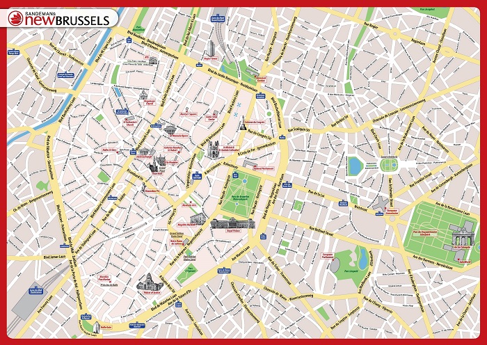
The attractions map highlights Brussels most iconic sights, including the Grand Place, Manneken Pis, Atomium, Royal Palace of Brussels, Mont des Arts and the St Michael and St Gudula Cathedral. These landmarks showcase the heart of the citys history and architecture, and the map shows their exact locations across central Brussels to help you plan walking routes between major sights.
Brussels is also known for its impressive collection of museums, and the map marks key cultural institutions such as the Magritte Museum, Royal Museums of Fine Arts, Belgian Comic Strip Center, Art and History Museum and the Museum of Musical Instruments. With attractions located around Mont des Arts and the European Quarter, the tourist map helps you link museum visits with nearby viewpoints, gardens and historic streets.
Neighborhoods such as Sablon, Marolles, Ixelles and the European Quarter are also featured on the map. These areas offer antique markets, chocolate shops, sidewalk cafes, EU institutions and lively public squares. The map helps you identify these districts clearly so you can explore their highlights and understand how they connect through metro lines, tram routes and walkable paths.
For visitors interested in political and modern architecture, the map marks important sites in the European Quarter, including the European Parliament, Parlamentarium and surrounding parks and squares. These attractions offer a deeper look into the political heart of the European Union and are easy to reach with clear map guidance.
Travelers searching for Brussels attraction tickets will find the map useful for pinpointing entrances and ticket offices for busier attractions such as the Atomium, panoramic viewpoints and major museums. Planning ahead with the map allows you to avoid unnecessary walking and make the most of your time in the city.
Whether you want to explore medieval squares, wander through art districts, discover modern architecture or visit chocolate shops and galleries, the Brussels Tourist Attractions Map provides a complete overview of the citys top places to visit. It helps you group nearby attractions, plan efficient sightseeing routes and enjoy Brussels at your own pace.
Scroll down to view the full attractions map and start planning your journey through Brussels most famous landmarks, cultural districts and must see highlights.
Frequently Asked Questions About Brussels Tourist Attractions
1. What are the top tourist attractions to visit in Brussels?
Must see attractions include the Grand Place, Atomium, Manneken Pis, Royal Palace, Mont des Arts, St Michael and St Gudula Cathedral and the Magritte Museum.
2. How does the Brussels tourist attractions map help visitors?
The map shows the location of major landmarks across the city center, Sablon, Marolles and the European Quarter. It helps visitors plan walking routes and understand public transport connections.
3. Are Brussels attractions walkable?
Many central attractions, including the Grand Place and nearby museums, are within walking distance. The map highlights the best paths for moving between historic areas.
4. Do Brussels attractions require tickets?
Sites like the Atomium, museums and panoramic viewpoints require tickets. The map helps you locate entrance points and ticket counters for these attractions.
5. What is the best area for sightseeing in Brussels?
The Grand Place area is ideal for history, Mont des Arts for museums, Sablon for antique markets and the European Quarter for modern architecture. The map shows how these districts link together.
6. How can I plan one day of sightseeing in Brussels?
A good day includes the Grand Place, Royal Palace, Mont des Arts and Atomium. The attractions map helps you arrange these highlights in a time saving and efficient route.
Top Brussels Attractions Skip-the-line Tickets & Tours
Belgium’s capital city is a compact one full of history and ancient architectural attractions. The city is a melting pot of different atmosphere, which showcases the entirety of Europe in one setting. Brussels is very proud owner of its flower covered Grand Palace, its world famous chocolate and waffles and the city’s own mascot, the Mannekin Pis.
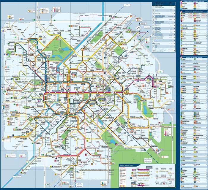
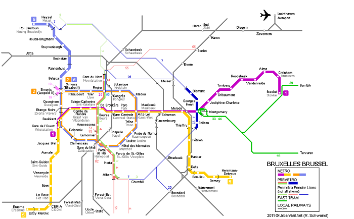
The good news is getting around this wonderful city is made easy due to a number of available transportation options such as the public bus or the metro service. You can also opt to rent a bike or share a car. Just make sure to have a copy of the Brussels Metro Map andthe Brussels Transport Map. Both maps are useful for making your trip memorable as it shows in detail where best to go if you are looking for a specific event, restaurant or location to explore.
If you want to explore Brussels famous attractions, get a copy of the BrusselsTourist Sightseeing Map. This map will be your guide into the city’s major tourist destination like the Atomium, Belgian Comic Strip Center, Belgian Royal Museum of Fine Arts, Grand Palace, Mannekin Pis, Royal Palace, Saint-Michel Cathedral, Mont des Arts and so many more!
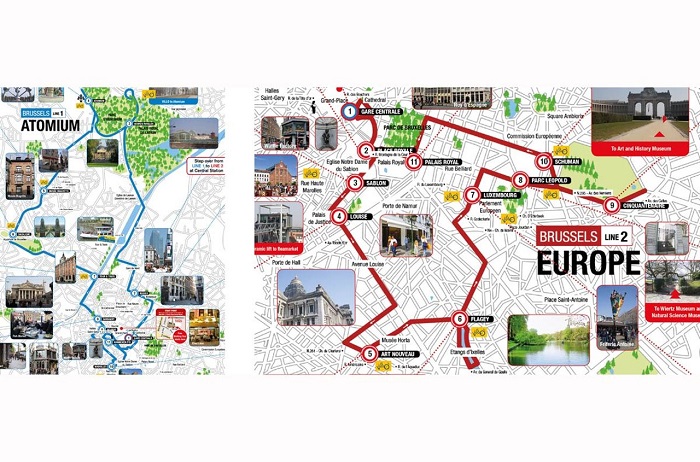
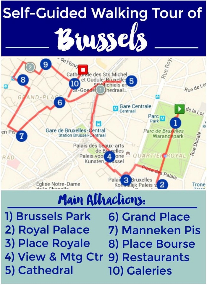
Many of the tourist spots in Brussels are located in close proximity with each other and within walking distance so going on foot is not a problem. To help you locate which amazing sights are within the area, make use of the Brussels Walking Tour Maps. There’s a walking map that will surely suit your need that you can follow or you can make your own!
The Brussels Hop on Hop off Bus Tour is also available for those who just want to enjoy the view and observe comfortably. Plan your tour ahead by checking the bus schedules and getting the free printable copy of the Brussels Hop on Hop off Bus map.
Read More See Less