Krakow Tourist Attractions Maps | City Tours Map
Your Complete Guide to the Krakow Tourist Attractions Map
Krakow is one of Europes most captivating historic cities, known for its medieval architecture, royal landmarks, riverside scenery and deeply preserved cultural heritage. With major attractions spread across the Old Town, Wawel Hill, Kazimierz, Podgorze, Nowa Huta and the riverside districts, having a clear tourist attractions map is essential for planning your visit. This guide brings together all the important Krakow tourist attractions in one place, helping you explore museums, squares, churches, markets and historical sites with ease.
The attractions map highlights Krakows most famous landmarks, including the Main Market Square, Cloth Hall, St Marys Basilica, Wawel Castle and the Wawel Cathedral. These historic icons lie at the heart of the city, and the map helps visitors navigate the medieval Old Town layout, which is filled with narrow lanes, charming courtyards and elegant landmarks.
The map also features the Jewish Quarter of Kazimierz, home to important cultural attractions such as the Old Synagogue, Remuh Synagogue, Galicia Jewish Museum and vibrant squares lined with cafes and art spaces. With this district offering a blend of heritage and modern culture, the attractions map helps visitors understand how to move between synagogues, museums and local streets.
Across the river in Podgorze, key attractions such as the Ghetto Heroes Square, Oskar Schindlers Enamel Factory and Ghetto Wall Memorial are clearly marked. These significant historical sites require planning due to their location outside the Old Town, and the map helps travellers organise efficient routes that combine river crossings, walking paths and public transport options.
Krakow’s museums and cultural institutions are also covered on the map, including the National Museum, Czartoryski Museum, MOCAK Museum of Contemporary Art and Rynek Underground Museum. These attractions sit throughout various districts, and the map helps visitors group nearby museums to save time and explore more comfortably.
Nature and outdoor attractions such as Planty Park, Vistula River Boulevards, Zakrzowek Quarry and scenic walking routes are also highlighted. These spots offer peaceful green spaces, river views and opportunities for active sightseeing, and the map helps you identify the best access points.
Travellers looking for Krakow attraction tickets will find the map especially useful for identifying entrances and ticket areas for Wawel Castle, Rynek Underground Museum, St Marys Basilica and Schindlers Factory. This allows visitors to plan ahead and avoid long queues at popular sites.
Whether you want to explore medieval streets, visit royal monuments, reflect at historical memorials or discover cultural neighborhoods, the Krakow Tourist Attractions Map provides a clear and complete overview of the citys best places to visit. It helps you connect districts, plan efficient routes and enjoy Krakow at your own pace.
Scroll down to view the full attractions map and start planning your Krakow journey through Old Town treasures, riverside paths, historic districts and must see landmarks.
Frequently Asked Questions About Krakow Tourist Attractions
1. What are the top tourist attractions in Krakow?
The top attractions include Main Market Square, Wawel Castle, St Marys Basilica, Kazimierz Jewish Quarter, the Cloth Hall and Schindlers Factory.
2. How does the Krakow tourist attractions map help visitors?
The map shows where major landmarks, museums, memorials and riverfront paths are located across the city, helping visitors plan a smooth sightseeing route.
3. Are Krakow attractions walkable?
Yes, many attractions in the Old Town and Kazimierz are walkable. The map highlights pedestrian routes, river crossings and nearby transit stops.
4. Do Krakow attractions require tickets?
Sites like Wawel Castle, Rynek Underground and Schindlers Factory require tickets. The map helps visitors locate entrances and ticket counters.
5. What is the best area for sightseeing in Krakow?
The Old Town is ideal for medieval sites, Kazimierz for cultural attractions, and Podgorze for historical memorials. The map outlines each district clearly.
6. How can I plan one day of sightseeing in Krakow?
A popular one day itinerary includes Main Market Square, Wawel Castle, Kazimierz and the Vistula Boulevards. The attractions map helps order these stops efficiently.
Top Krakow Attractions Skip-the-line Tickets & Tours
Krakow Guided Tour to Iconic Polish Royal Residence Wawel Castle
Museum of illusions Entry Ticket
Schindler’s Factory Visit & Skip-the-Line Entry
Schindler's Factory Museum Guided Tour with skip-the-line entry
Zakopane - private tour to the town at foot of Tatra Mountains
Auschwitz - Birkenau Museum and Memorial Private tour
Wieliczka Salt Mine Walking Guided Tour with Fast-Track Ticket
Schindler's Factory, Old Synagogue, Remuh Synagogue - Discount Monday in Kraków
Krakow is surrounded with interesting historical sights lying at the banks of Vistula River. It’s a great city for sightseeing and enjoying delicious Polish cuisines. The Old Town center is where most of the historical attractions can be found.
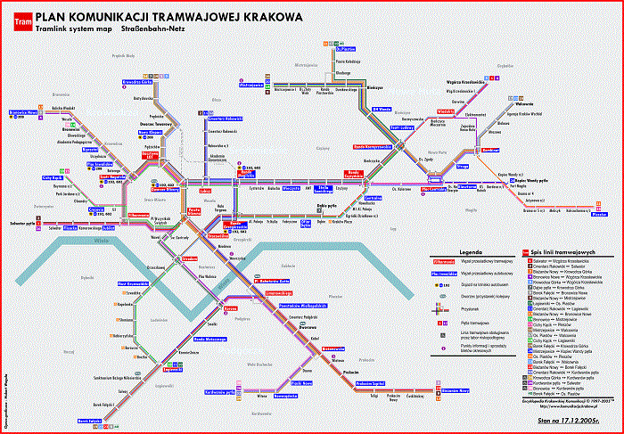
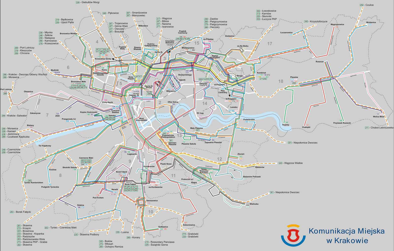
When exploring Krakow, you can greatly benefit from the Krakow metro map. With this map, you’ll be able to discover the city on your own, without having to spend a lot of money on transportation. The Krakow Transport Map will also tell you what bus to take if you’re going to explore the various tourist sights of the city. If you plan on exploring outside the city center, this map will surely be a big help.
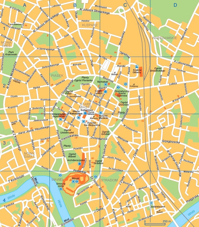
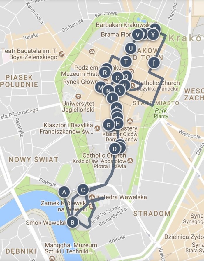
For information on where to find the tourist attractions in Krakow, do check out the Krakow Tourist Sightseeing Map. This map will inform you where to find the famous sights like Kraków Old Town, Wawel Royal Castle, The Cloth Hall, Wieliczka Salt Mine, and the Main Town Square. Of course, there are also a number of museums and galleries that are definitely worth a visit so you better check them out.
Most of Krakow’s historic areas are covered with pedestrian zone, which allows you to easily explore the city on foot. When it comes to this, our free printable Krakow Walking Tour Maps would be a big help. These maps will serve as your guide into exploring the city’s famous sights on foot.
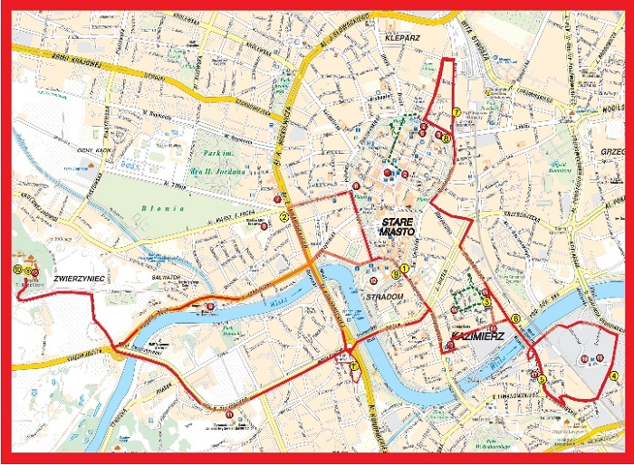
If you want a more comfortable way of getting around the city, you might want to join in one of the Hop on Hop off Bus tours. These tours are also ideal for those who are traveling with kids. You’ll find information on where the bus would pass by on the Krakow Hop on Hop off bus map. So get our free printable copy now.
Read More See Less