Kuala Lumpur Tourist Attractions Maps | City Tours Map
Your Complete Guide to the Kuala Lumpur Tourist Attractions Map
Kuala Lumpur is a city where modern skyscrapers, colorful cultural districts, historic temples and lush green parks come together to create one of Southeast Asia's most vibrant destinations. With major attractions located across KLCC, Bukit Bintang, Chinatown, Little India, Brickfields, Batu Caves and Lake Gardens, having a clear tourist attractions map is essential for planning your sightseeing. This guide gathers the most important Kuala Lumpur tourist attractions in one place, helping you explore landmarks, markets, museums and viewpoints with ease.
The attractions map highlights Kuala Lumpur’s most iconic sights, including the Petronas Twin Towers, KLCC Park, KL Tower, Merdeka Square and the Sultan Abdul Samad Building. These landmarks represent the city’s blend of modern architecture and colonial heritage. The map shows their exact positions, allowing visitors to plan walking routes across downtown districts with clear direction and convenience.
Cultural districts such as Chinatown and Little India are also featured on the map, showcasing attractions like Petaling Street Market, Sin Sze Si Ya Temple, Sri Mahamariamman Temple and Bangsar’s cultural streets. These vibrant areas are filled with local food, shops and historical sites, and the map helps visitors navigate busy streets and hidden corners that define Kuala Lumpur’s cultural identity.
The map also highlights major religious and heritage attractions, such as the famous Batu Caves, Thean Hou Temple, National Mosque and Islamic Arts Museum. These sites sit across different areas of the city, and the attractions map helps travelers plan routes using trains, walking connections and short transfers to reach these important cultural landmarks.
Nature and outdoor attractions are displayed as well, including Perdana Botanical Garden, KL Bird Park, KL Butterfly Park and scenic areas around Lake Gardens. The map clearly marks entrances, pathways and recommended viewing spots to help visitors enjoy green spaces and family friendly attractions.
Kuala Lumpur’s modern entertainment and shopping districts, such as Bukit Bintang, Pavilion KL, Suria KLCC and Avenue K, are highlighted across the map. These areas offer dining, malls and nightlife, and the map helps visitors understand how to connect these zones using pedestrian bridges, monorail stations and well marked streets.
Travelers searching for Kuala Lumpur attraction tickets will find the map helpful for identifying entrances and ticket counters for popular sites such as the Petronas Towers Skybridge, KL Tower observation deck, museums and cultural landmarks. This helps visitors reduce waiting times and plan a smooth itinerary.
Whether you want to enjoy panoramic city views, discover cultural neighborhoods, explore nature parks or visit world class shopping areas, the Kuala Lumpur Tourist Attractions Map provides a complete overview of the city’s best places to visit. It helps you group nearby attractions, understand transport connections and explore Kuala Lumpur at your own pace.
Scroll down to view the full attractions map and begin planning your Kuala Lumpur journey through skylines, heritage areas and must see landmarks.
Frequently Asked Questions About Kuala Lumpur Tourist Attractions
1. What are the top attractions in Kuala Lumpur?
Popular attractions include the Petronas Twin Towers, KL Tower, Batu Caves, Merdeka Square, Chinatown and Perdana Botanical Garden.
2. How does the Kuala Lumpur tourist attractions map help visitors?
The map shows where major sights are located across KLCC, Chinatown, Bukit Bintang and outer districts. It helps visitors plan walking routes and public transport connections.
3. Are Kuala Lumpur attractions easy to reach?
Yes, many attractions are connected by LRT, MRT, monorail and well marked pedestrian routes. The map highlights the nearest stations and paths.
4. Do Kuala Lumpur attractions require tickets?
Sites like the Petronas Towers, KL Tower and some museums require tickets. The map shows entrances and ticket points clearly.
5. What is the best area for sightseeing in Kuala Lumpur?
KLCC is ideal for skyline views, Chinatown for culture, Bukit Bintang for shopping and dining, and Lake Gardens for nature. The map outlines these areas clearly.
6. How can I plan one day of sightseeing in Kuala Lumpur?
A common route includes the Petronas Towers, Chinatown, Merdeka Square and KL Tower. The attractions map helps arrange these stops efficiently.
Top Kuala Lumpur Attractions Skip-the-line Tickets & Tours
Skip the Line: Petronas Twin Towers & Kuala Lumpur Tower Observation Deck Ticket
Museum Of Illusions Kuala Lumpur Admission Ticket
Skip the Line: Petronas Twin Towers Ticket With Free Hotel Delivery
Malacca Day Tour (Price based per car)
KL Tower Admission Tickets
Cruise Tasik Putrajaya Admission Ticket
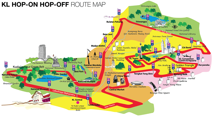
KL Hop-On Hop-Off Sightseeing Bus Pass (24/48 Hours)
Malaysia Cultural Kuala Lumpur Tour (with tour guide)
Malaysia’s capital city is known for its modern skyline dominated by the towering Petronas Towers and KL Tower. But aside from the modern skyscrapers, Kuala Lumpur is also known as a great shopping and dining destination in Southeast Asia. Of course, there are also lots of interesting sights to see in the city especially in the colorful streets of Little India and Chinatown.
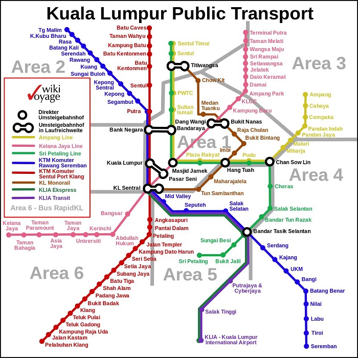
Thankfully, getting around Kuala Lumpur is so easy, thanks to its modern train system. For as long as you have a copy of the Kuala Lumpur metro map, exploring this vibrant Malaysian city should be a breeze. Whether you’re heading to Kuala Lumpur to shop, dine, or explore, you can greatly benefit from the use of a Kuala Lumpur Transport Map. With this map, you’d be able to get around the city using the most comfortable mode of public transportation, such as the Light Rail Transit, Monorail, or public bus.
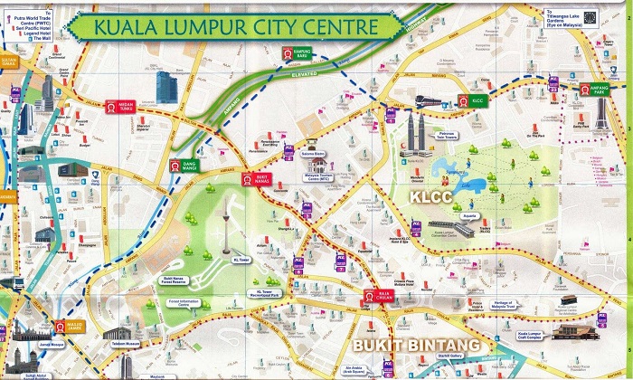
For tourists who wanted to explore Kuala Lumpur’s famous attractions, you should get yourself a copy of the Kuala Lumpur Tourist Sightseeing Map. This map will serve as your guide to exploring the city’s famous sights, including the Petronas Towers, KL Tower, Chinatown, Little India, National Palace, Sultan Abdul Samad Building, and the Perdana Botanical Gardens. The map also includes instructions on how to visit the city’s most famous monuments and museums.
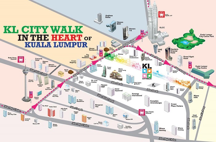
It’s also possible to walk around Kuala Lumpur during your tour. When it comes to this, the Kuala Lumpur Walking Tour Maps would benefit you the most. It provides information on how you can explore some tourist sights in the city, depending on the type of traveler that you are. There’s a walking map for cultural tours, for visiting museums and monuments, discovering colonial architectures, and more!
For tourists who would prefer a more comfortable way of exploring the city, taking the Hop on Hop off Bus tour is highly recommended. This is especially applicable to those who are traveling with some elders and kids. If you want to know where you can catch the bus, we have a free printable copy of the Kuala Lumpur Hop on Hop off Bus map.
Read More See Less