Las Vegas Tourist Attractions Maps | City Tours Map
Your Complete Guide to the Las Vegas Tourist Attractions Map
Las Vegas is a one of a kind destination where world famous resorts, dazzling entertainment, themed attractions and natural wonders all come together in one unforgettable travel experience. With major attractions spread across the Las Vegas Strip, Downtown Las Vegas, Fremont Street, the Arts District and surrounding desert landscapes, having a clear tourist attractions map is essential for planning your visit. This guide brings together the most important Las Vegas tourist attractions, helping you explore shows, landmarks, museums, photo spots and outdoor highlights with ease.
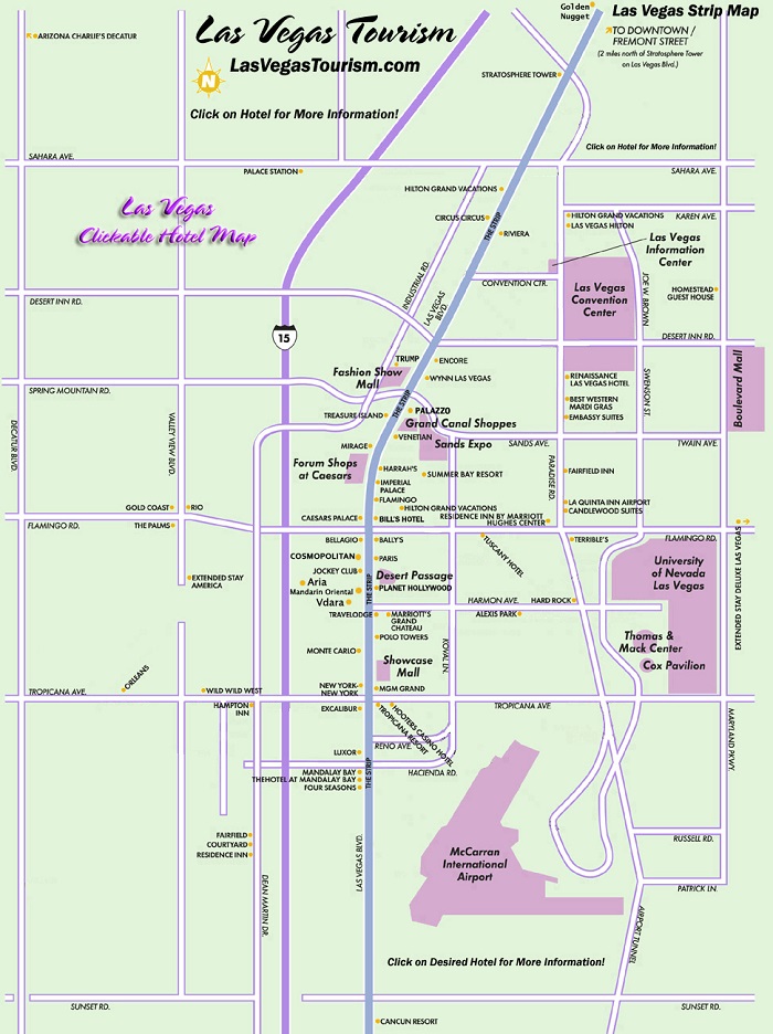
The attractions map highlights iconic locations along the Strip, including the Bellagio Fountains, High Roller Observation Wheel, Paris Eiffel Tower Viewpoint, The Venetian Grand Canal, The Sphere and Welcome to Fabulous Las Vegas Sign. These landmarks define the vibrant atmosphere of Las Vegas, and the map helps visitors understand walking distances and routes between major resorts and entertainment venues.
The map also features Downtown Las Vegas and the historic Fremont Street Experience, home to massive LED canopy shows, street performers, live music and classic casinos. With attractions such as the Mob Museum and Neon Museum located nearby, the map helps travelers navigate this lively district and explore its mix of history and nightlife.
Cultural attractions and museums are highlighted across the map, including the Las Vegas Natural History Museum, Discovery Childrens Museum, Madame Tussauds and unique themed exhibitions located inside major resorts. Spread throughout different areas, these attractions benefit from clear map guidance for planning efficient visits.
Outdoor lovers and adventure seekers will also find major natural attractions displayed on the map, such as Red Rock Canyon, Hoover Dam, Valley of Fire and scenic viewpoints around Lake Mead. Although outside the main city areas, these popular day trip destinations are included to help visitors understand driving routes and approximate travel distances.
For travelers focused on nightlife, performances and themed venues, the map highlights entertainment districts, show theaters, event arenas and attractions such as the Mirage Volcano, Treasure Island Pirate Show area and popular spots for panoramic city views. With so many entertainment options available, the map helps travelers locate venues quickly and plan their evenings with ease.
Visitors looking for Las Vegas attraction tickets will find the map especially helpful for identifying entrances, box offices and show locations. Whether you are planning a helicopter flight, museum visit or evening theater experience, the map helps you organise your route and avoid unnecessary travel time.
Whether you want to explore famous resorts, enjoy unforgettable shows, discover museums, photograph skyline views or venture out into the desert, the Las Vegas Tourist Attractions Map provides a complete overview of the city’s top places to visit. It helps you group nearby attractions, understand district layouts and experience Las Vegas at your own pace.
Scroll down to explore the full attractions map and begin planning your Las Vegas journey through world renowned entertainment, iconic landmarks and must see destinations.
Frequently Asked Questions About Las Vegas Tourist Attractions
1. What are the top tourist attractions in Las Vegas?
The most popular attractions include the Bellagio Fountains, High Roller, Fremont Street Experience, Neon Museum, The Sphere and the Welcome to Fabulous Las Vegas Sign.
2. How does the Las Vegas tourist attractions map help visitors?
The map shows the location of major sights across the Strip, Downtown and nearby natural areas, helping visitors plan routes and understand distances between attractions.
3. Are Las Vegas attractions walkable?
Many Strip attractions are walkable but spread out. The map highlights footbridges, pedestrian paths and resort to resort walking connections.
4. Do Las Vegas attractions require tickets?
Shows, museums, observation decks and some outdoor attractions require tickets. The map helps identify ticket counters and entrance locations.
5. What is the best area for sightseeing in Las Vegas?
The Strip is ideal for entertainment and resorts, Downtown for history and neon art, and Red Rock Canyon for outdoor scenery. The map outlines each zone clearly.
6. How can I plan one day of sightseeing in Las Vegas?
A popular one day route includes the Bellagio Fountains, High Roller, Fremont Street and a nighttime show. The map helps arrange these stops efficiently.
Top Las Vegas Attractions Skip-the-line Tickets & Tours
Go City: Las Vegas Explorer Pass - Choose 2, 3, 4, 5, 6 or 7 Attractions
Las Vegas Mob Museum Admission Ticket
Skip the Line: Springs Preserve in Las Vegas Admission Ticket
Tom Devlin's Monster Museum Self-Guided Tour
Skip the Line: Dimmare's Martinis and Magic® Ticket
Masters of Magic Show at Las Vegas Magic Theater
Witches and Warlocks Show.
Magic of Christmas Show at Las Vegas Magic Theater on Las Vegas Blvd
If you want to party, play at casinos, and indulge in some retail therapy, Las Vegas is the perfect destination for you. What’s great about Vegas is that you can have a great time in the city regardless of the season. It enjoys good weather all year round and there’s always something new to do for everyone. Although Las Vegas is known for being outrageously expensive, it’s definitely possible to have a great time in this party city with a limited budget.
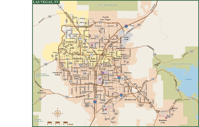
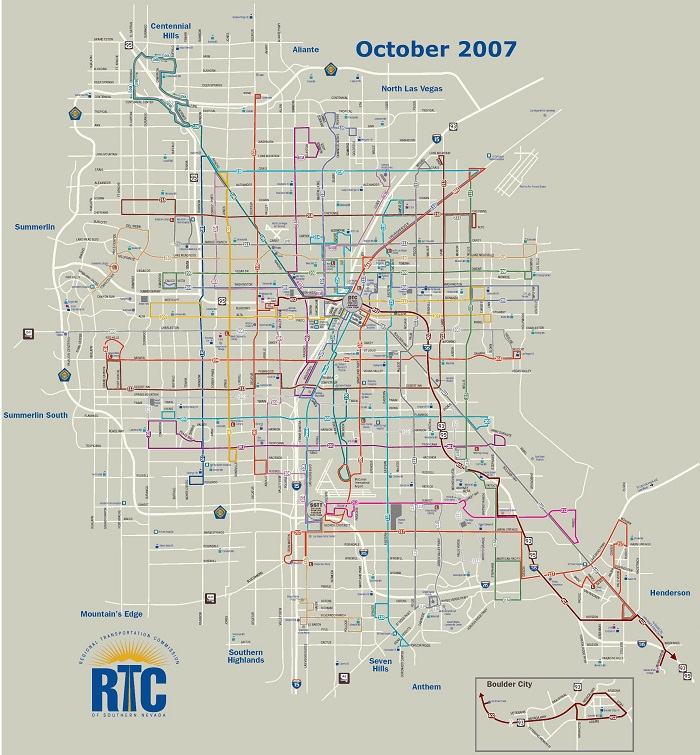
One way to save money on your Vegas holiday is to take advantage of the public transportation. We have provided a copy of the Las Vegas Transport Map to help you with this. The Las Vegas Monorail runs along the Strip, which is perhaps the most popular area in the city. It’s a cheap and convenient way to get around Vegas, so refer to our Las Vegas Metro Map to help you in using the monorail.
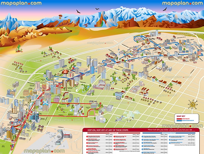
Of course, your Vegas trip won’t be complete without a bit of sightseeing. Aside from the luxury resorts and casinos, Las Vegas is also home to popular attractions such as the Red Rock Canyon National Conservation Park and the Fremont Street. Do check out our Las Vegas Tourist Sightseeing Map to find out what other attractions in Vegas are worth visiting.
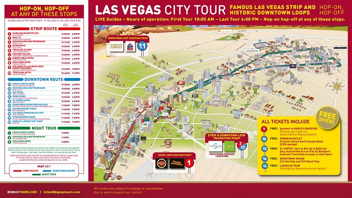
The hotels and casinos in Las Vegas are a walking distance away from each other. Therefore, the best way to get around Vegas is by foot. To ensure your safety, use our Las Vegas Walking Tour Maps and find out which places in Vegas are pedestrian-friendly. You can also hop in one of the tour buses running the streets in Vegas if you want a more comfortable way of discovering the city. Our free printable copy of the Las Vegas Hop on Hop Off Bus Map should give you an idea on where these buses will take you.
Read More See Less