Los Angeles Tourist Attractions Maps | City Tours Map
Your Complete Guide to the Los Angeles Tourist Attractions Map
Los Angeles is a city of iconic landmarks, world famous entertainment districts, sun filled coastlines and cultural neighborhoods that attract millions of visitors every year. With major attractions spread across Hollywood, Beverly Hills, Downtown LA, Santa Monica, Venice Beach and the surrounding canyon and mountain areas, a clear tourist attractions map is essential for planning your trip. This guide brings together all the important Los Angeles tourist attractions, helping you navigate viewpoints, museums, film locations, beaches and entertainment hubs with ease.
The attractions map highlights LA's most recognizable landmarks including the Hollywood Sign, Hollywood Walk of Fame, Griffith Observatory, Dolby Theatre, Santa Monica Pier and Rodeo Drive. These locations define the city's global identity, and the map helps visitors understand the travel routes between hillside viewpoints, coastal attractions and Hollywood’s entertainment district.
Cultural attractions are also clearly displayed across the map, including the Los Angeles County Museum of Art, The Broad, Getty Center, El Pueblo Historic Monument and the Walt Disney Concert Hall. Spread across different neighborhoods, these sites offer a mix of art, architecture and history, and the map helps visitors group museums that are located close to one another for time efficient sightseeing.
The map features LA’s famous coastal districts including Santa Monica, Venice Beach, Marina del Rey and viewpoints along the Pacific Coast Highway. These areas offer beaches, boardwalks, bike paths and ocean views, and the attractions map helps visitors identify the best routes for walking, cycling or enjoying sunset viewpoints along the coast.
For travelers interested in entertainment and family friendly attractions, the map displays must visit destinations such as Universal Studios Hollywood, Warner Bros Studio Tour, La Brea Tar Pits and Los Angeles Zoo. These attractions sit in different districts, and the map helps visitors understand transport connections and driving routes between studio tours and museum zones.
Outdoor lovers will find major natural attractions marked across the map, including Runyon Canyon, Griffith Park, Mulholland Drive viewpoints and the scenic trails around the Santa Monica Mountains. The map highlights trailheads, scenic overlooks and park entrances so visitors can plan safe and enjoyable outdoor activities.
Shopping, entertainment and nightlife areas such as The Grove, Melrose Avenue, Sunset Strip, LA Live and Grand Central Market are also displayed. With so many districts spread across a large metro area, the map helps travelers decide which zones to combine into one day of exploring.
Visitors looking for Los Angeles attraction tickets will find the map especially useful for locating entrances, ticket booths and visitor centers across major sites such as Universal Studios, Griffith Observatory areas, Hollywood museums and coastal attractions. This helps travelers plan their timing and avoid unnecessary detours.
Whether you want to explore Hollywood history, enjoy coastal scenery, visit world class museums or experience LA’s famous entertainment culture, the Los Angeles Tourist Attractions Map provides a complete overview of the city’s must see locations. It helps you group nearby attractions, plan practical routes and enjoy Los Angeles at your own pace.
Scroll down to explore the full attractions map and begin planning your Los Angeles journey through iconic neighborhoods, scenic lookouts and popular cultural sites.
Frequently Asked Questions About Los Angeles Tourist Attractions
1. What are the top tourist attractions in Los Angeles?
Popular attractions include the Hollywood Sign, Santa Monica Pier, Griffith Observatory, Walk of Fame, Universal Studios Hollywood and the Getty Center.
2. How does the Los Angeles tourist attractions map help visitors?
The map shows where major landmarks, museums and coastal areas are located across the city, helping visitors understand travel routes and plan efficient sightseeing.
3. Are Los Angeles attractions easy to reach?
Many attractions require short drives or transit connections. The map highlights major roads, transport hubs and walkable districts to simplify planning.
4. Do Los Angeles attractions require tickets?
Popular attractions such as Universal Studios, studio tours, museums and observation decks require tickets. The map shows entrance areas and ticket points.
5. What is the best area for sightseeing in Los Angeles?
Hollywood is ideal for film history, Santa Monica for beaches, Downtown LA for culture and Griffith Park for nature. The map outlines each area clearly.
6. How can I plan one day of sightseeing in Los Angeles?
A common itinerary includes Griffith Observatory, Hollywood Boulevard, Santa Monica and a sunset at Venice Beach. The attractions map helps arrange these stops smoothly.
Top Los Angeles Attractions Skip-the-line Tickets & Tours
Admission: Natural History Museum of Los Angeles County
La Brea Tar Pits and Museum Admission Ticket with Excavator Tour
Madame Tussauds Hollywood Admission Ticket
Skip the Line: General Admission Museum of Tolerance Ticket
Best Ferrari California T Private Tour to Hollywood Sign View Point
Skip the Line: Express Ticket at Universal Studios Hollywood
Go City: Los Angeles All-Inclusive Pass: 40+ Attractions and Tours
Go City: Los Angeles Explorer Pass - Choose any 2, 3, 4, 5 or 7 Attractions
The beaches, the food, the shopping options, the scenic view, the endless sunshine, the lingering sunsets, and the glitz and the glamour of La La Land -- you will never run out of reasons to visit Los Angeles. With a record high of 50 million visitors in 2018, this sprawling Southern California city is no doubt one of the top tourist destinations in the United States.
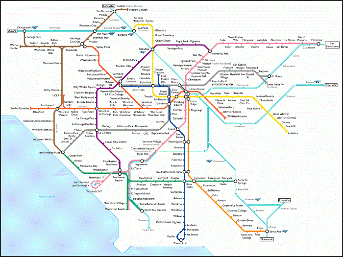
Notorious for its traffic, Los Angeles poses a bit of a challenge for its visitors. However, getting around Los Angeles could turn out surprisingly pleasant with a tad of creativity, wise planning, and a little help from the Los Angeles metro map. Although not as well-praised as other metro networks, the Los Angeles Metro Rail System is still the most convenient and affordable means of exploring the city. To navigate the city at your pace, be sure to get a copy of the Los Angeles Transport Map.
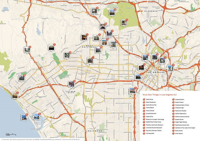
To make the most out of your stay in Los Angeles, plan your itinerary carefully using the Los Angeles Tourist Sightseeing Map. Satisfy your palate in one of the finest restaurants in downtown Los Angeles, watch a performance at the Hollywood Bowl, ride the solar-powered Ferris wheel at the Santa Monica pier, or shop at a vintage clothing store in West Hollywood. The map includes detailed instructions on how to get to the city's top attractions.
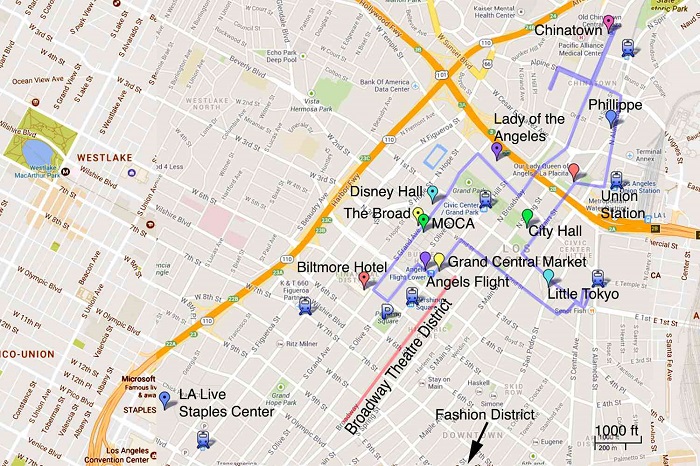
Los Angeles is a massive city, and exploring its many sights on foot could be a little tricky. It is best to focus on the most walkable parts of the city. Take, for instance, Hollywood. You can stroll along the Walk of Fame and spot the names of your favorite celebrities; check out the eccentric boutiques and landmark bistros at Melrose Avenue; then, catch a show on Sunset Boulevard. To help you decide which neighborhoods to visit, get a copy of the Los Angeles Walking Tour Maps. The map focuses on a variety of options that allows you to pick a tour, depending on your preference.
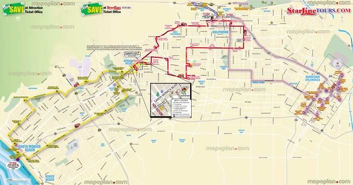
If you are traveling with elders and kids, we recommend that you book the Hop on Hop off Bus tour for comfort and convenience. To find out more about the bus routes, refer to our free printable Los Angeles Hop on Hop on Bus map.
Read More See Less