Mexico City Tourist Attractions Maps | City Tours Map
Your Complete Guide to the Mexico City Tourist Attractions Map
Mexico City is one of the most vibrant cultural capitals in the world, filled with ancient ruins, grand plazas, colonial districts, modern museums and colorful neighborhoods that reflect its rich heritage. With major attractions spread across the Historic Center, Chapultepec Park, Roma, Condesa, Polanco, Coyoacan and Xochimilco, a clear tourist attractions map is essential for planning your visit. This guide brings together the most important Mexico City tourist attractions, helping you explore museums, landmarks, markets and cultural highlights with ease.
The attractions map highlights the city’s most iconic landmarks including the Zocalo, Metropolitan Cathedral, Templo Mayor, Palacio de Bellas Artes and Torre Latinoamericana. These historic sites sit within the heart of the Historic Center, and the map helps visitors understand the layout of plazas, pedestrian streets and surrounding cultural buildings.
Museums and cultural institutions are clearly displayed throughout the map, including the National Museum of Anthropology, Frida Kahlo Museum in Coyoacan, the Soumaya Museum, Tamayo Museum, Chapultepec Castle and the Memory and Tolerance Museum. With these attractions located across different districts, the map helps travelers plan efficient routes and group nearby museums in a single visit.
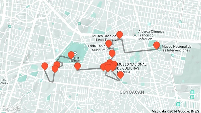
Mexico City’s famous neighborhoods are also highlighted, such as Roma, Condesa, Polanco, Coyoacan and San Angel. These districts are known for leafy streets, cafes, art galleries and traditional markets. The attractions map helps visitors navigate between cultural spots, boutique areas and architectural landmarks within each neighborhood.
The map includes major outdoor and nature areas such as Chapultepec Forest, Lake Chapultepec, Bosque de Tlalpan and scenic walking paths. As one of the largest urban parks in the world, Chapultepec Park contains numerous attractions within its grounds, and the map helps visitors locate viewpoints, museums, gardens and lakeside areas.
Traditional cultural attractions such as Xochimilco’s canals, floating gardens, trajineras and nearby markets are also shown on the map, helping travelers understand routes and access points for this colorful and historic UNESCO listed area.
The map features important archaeological attractions including Teotihuacan Pyramids, located outside the city. Although this site requires a day trip, it is included to help visitors understand distance, travel direction and nearby connecting routes.
Travelers looking for Mexico City attraction tickets will find the map useful for identifying entrances, ticket offices and visitor centers at popular spots such as the Anthropology Museum, Chapultepec Castle, Frida Kahlo Museum, Bellas Artes and archaeological sites.
Whether you want to explore ancient ruins, wander through historic plazas, enjoy world class museums or relax in leafy neighborhoods, the Mexico City Tourist Attractions Map provides a complete overview of the city’s best places to visit. It helps you group attractions by district, plan time saving routes and enjoy Mexico City at your own pace.
Scroll down to explore the full attractions map and begin planning your Mexico City journey through art, history, culture and unforgettable local neighborhoods.
Frequently Asked Questions About Mexico City Tourist Attractions
1. What are the top tourist attractions in Mexico City?
The top sights include the Zocalo, Metropolitan Cathedral, Templo Mayor, Chapultepec Castle, Frida Kahlo Museum and the National Museum of Anthropology.
2. How does the Mexico City tourist attractions map help visitors?
The map shows major museums, historic districts and green spaces across the city, helping visitors create efficient sightseeing routes and understand transport connections.
3. Are Mexico City attractions easy to reach?
Many attractions are accessible by Metro, buses or walking within central districts. The map highlights stations and travel paths for easy planning.
4. Do Mexico City attractions require tickets?
Museums, archaeological sites and some historic buildings require tickets. The map identifies entrances and ticket points.
5. What is the best area for sightseeing in Mexico City?
The Historic Center is ideal for monuments, Chapultepec for museums and parks, and Coyoacan for cultural attractions. The map outlines each area clearly.
6. How can I plan one day of sightseeing in Mexico City?
A common route includes the Zocalo, Bellas Artes, Chapultepec Park and Roma district. The attractions map helps organise these stops efficiently.
Top Mexico City Attractions Skip-the-line Tickets & Tours
11 days by the Aztec and Mayan Route:Puebla, Oaxaca, Chiapas, Yucatan and Cancun
Frida Kahlo Museum Tickets with Self-Guided Tour in Mexico
Teotihuacan Underground Experience
Subterranean Theater Entrance Ticket in Teotihuacán with Food
Ticket to the Tequila and Mezcal Museum and tasting
Tour to the Frida Kahlo Museum
Admission and Digital guide to the National Anthropology Museum
Private Tour to Chapultepec Castle
The city of Mexico is slowly becoming one of the world’s most popular tourist destinations. Although it has received a lot of negative publicity in the recent years, it’s actually a safe and interesting city to explore. It’s home to world class museums, interesting archeological sights, varied cultural attractions, and restaurants serving the tastiest Mexican cuisines!
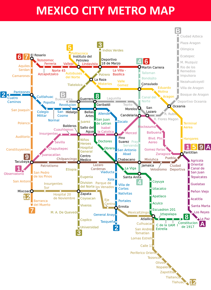
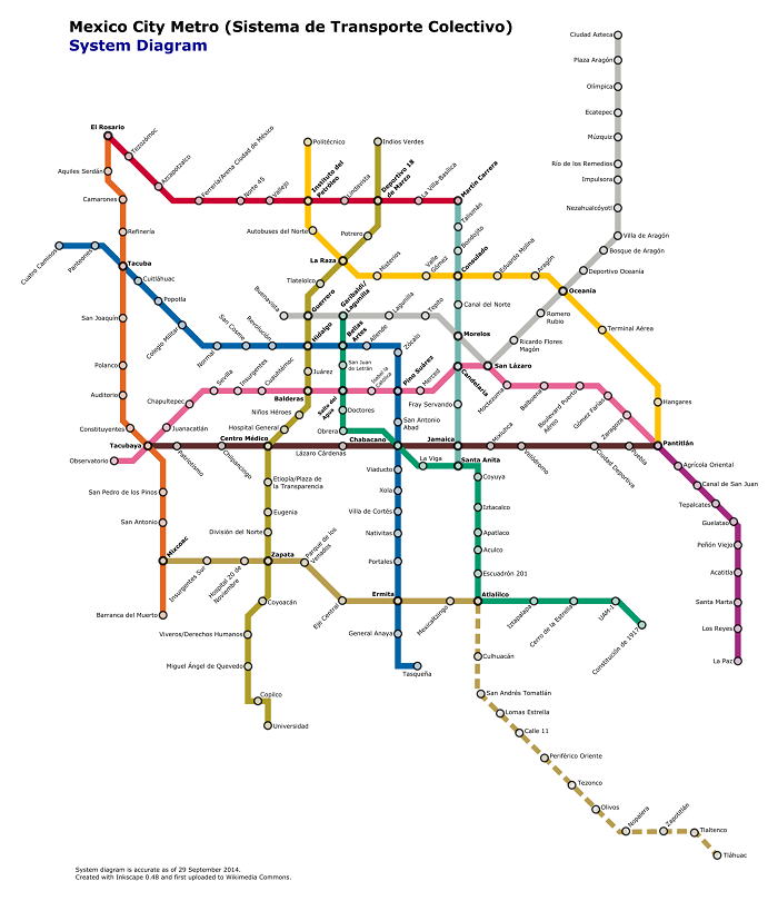
Using the public transportation in Mexico is safe and easy. So if you want to save money on your trip, we suggest taking the public buses. You can refer to our copy of the Mexico City Transport Map for this. There are also certain areas in Mexico that can be accessed by rail. If you want to explore this area, our Mexico City Metro Map will be a big help for you.
Of course, your trip to Mexico City won’t be complete without doing some sightseeing. One of the most famous sights that you should see in Mexico is the Chichen Itza, a UNESCO World Heritage Site that’s declared one of the New Seven wonders of the World. There are also tons of historical landmarks and fascinating architectures that are worth visiting in Mexico. Our Mexico City Sightseeing Map can give you tips on the best sights to see on your Mexico trip.
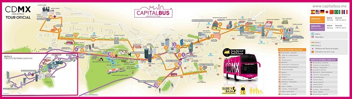
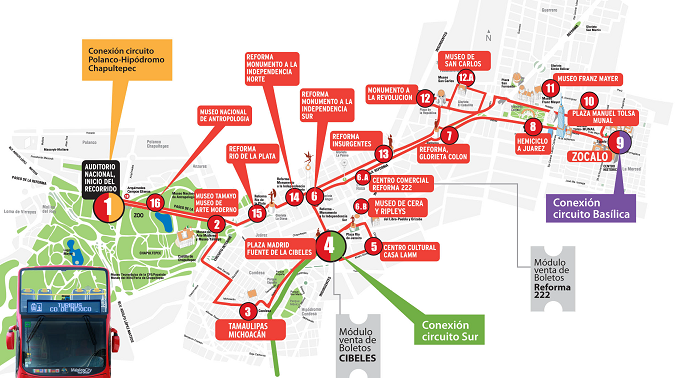
Of course, it’s possible to explore Mexico City by foot. For instance, you can wander around the historic center of Mexico City to check out the various historical landmarks in the area. We have a free printable copy of the Mexico City Walking Tour Maps that can serve as your guide to exploring the city by foot. And if you want to visit other places that you cannot reach by walking, join one of the open bus tours. Our Mexico City Hop on Hop Off Bus Maps will tell you which routes these buses will travel to.
Read More See Less