Toronto Tourist Attractions Maps | City Tours Map
Your Complete Guide to the Toronto Tourist Attractions Map
Toronto is a lively and multicultural city known for its iconic skyline, world class museums, scenic waterfront and vibrant neighborhoods. With major attractions spread across Downtown, Harbourfront, Distillery District, Yorkville, Queen West, Midtown and the Toronto Islands, a detailed tourist attractions map is essential for planning your visit. This guide highlights the most important Toronto tourist attractions, helping you explore landmarks, museums, parks, districts and viewpoints with confidence.
The attractions map features Toronto’s most recognizable sights including the CN Tower, Harbourfront Centre, Rogers Centre, Ripley’s Aquarium of Canada, Casa Loma and the Royal Ontario Museum. These major attractions are located across the downtown core and nearby districts, and the map helps visitors understand walking routes, streetcar lines and subway access points connecting each landmark.
Toronto’s cultural institutions and historic areas are also clearly displayed, such as the Art Gallery of Ontario, Hockey Hall of Fame, Distillery District, St. Lawrence Market and Fort York National Historic Site. These cultural hubs showcase Canadian history, global art, unique food markets and restored heritage buildings. The attractions map helps visitors combine nearby sites to build efficient sightseeing days.
The map highlights Toronto’s popular waterfront areas including Queen’s Quay, Martin Goodman Trail, Harbour Square Park and ferry terminals leading to the Toronto Islands. These waterfront zones offer bike paths, lake views, green spaces, beaches and recreation areas. The attractions map helps visitors find ferry routes, walking paths and viewpoints around Lake Ontario.
Toronto’s most vibrant neighborhoods are also included, such as Kensington Market, Chinatown, Greektown, The Annex, Yorkville and Queen West. These areas feature boutiques, mural-filled streets, cafes, restaurants, music venues and cultural festivals. The map guides visitors through these districts and highlights key streets worth exploring.
Major parks and green spaces including High Park, Trinity Bellwoods Park, Allan Gardens, Riverdale Park and Toronto Music Garden are displayed across the map. These spots offer gardens, wildlife, walking trails, viewpoints and picnic lawns, and the map helps visitors identify entrances and public transport connections.
Observatories and viewpoints such as the CN Tower Lookout, Polson Pier Viewpoint and Riverdale Park East are highlighted to help visitors enjoy some of the best skyline views in Canada. The map shows optimal routes to each viewing spot.
Travelers seeking Toronto attraction tickets will find the map useful for locating entrance points, museum ticket counters, ferry docks and observatory access areas across Toronto’s top attractions.
Whether you want to explore art museums, enjoy waterfront walks, shop in diverse neighborhoods, take in panoramic views or visit historic markets, the Toronto Tourist Attractions Map provides a complete overview of the city’s best places to visit. It helps you plan sightseeing routes, connect nearby attractions and enjoy Toronto at your own pace.
Scroll down to view the full attractions map and begin planning your Toronto journey through cultural districts, lakefront scenery and iconic city landmarks.
Frequently Asked Questions About Toronto Tourist Attractions
1. What are the top tourist attractions in Toronto?
Key attractions include the CN Tower, Royal Ontario Museum, Art Gallery of Ontario, Distillery District, Toronto Islands and St. Lawrence Market.
2. How does the Toronto tourist attractions map help visitors?
The map displays landmarks, neighborhoods, parks and transport lines, helping visitors plan efficient sightseeing routes.
3. Are Toronto attractions walkable?
Many downtown attractions are walkable, and the map highlights walking paths, streetcar routes and subway stations for easy navigation.
4. Do Toronto attractions require tickets?
Some attractions such as CN Tower, museums and certain tours require tickets. The map identifies entrances and ticket points.
5. What is the best area for sightseeing in Toronto?
The Harbourfront is ideal for lake views, downtown for museums and landmarks, and Kensington Market for culture and food. The map outlines each area clearly.
6. How can I plan one day of sightseeing in Toronto?
A popular route includes CN Tower, Harbourfront, St. Lawrence Market, Distillery District and Kensington Market. The map helps organize these stops efficiently.
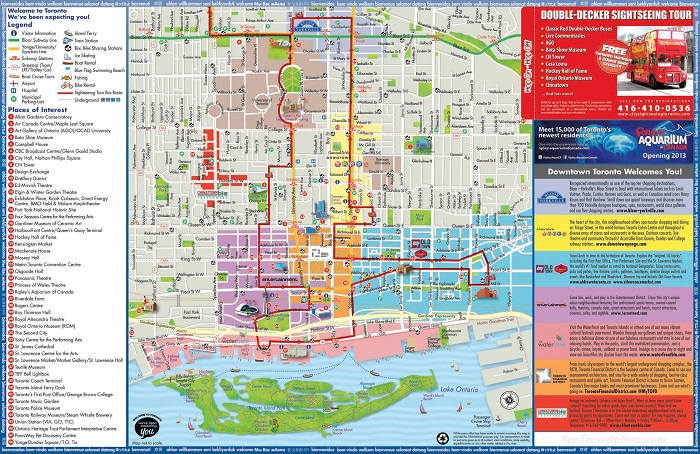
Top Toronto Attractions Skip-the-line Tickets & Tours
Toronto is a dynamic city that’s surrounded with towering skyscrapers and home to several great museums and galleries. It’s also where you’ll find the CN Tower, the tallest freestanding tower in North America. Despite being a cosmopolitan city, Toronto is still filled with lots of green spaces, such as the Queen’s Park and the 400-acre high park.
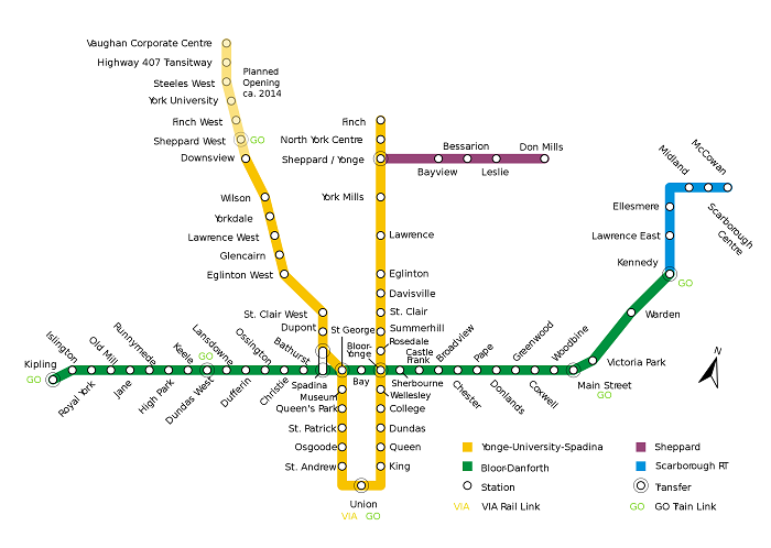
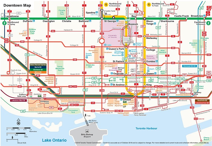
Thankfully, Toronto has an efficient public transportation system. This means that exploring the city on your own should be a breeze. The best way to explore Toronto is by taking the metro trains, which runs in and out of the Union Station. You can refer to our Toronto metro map if you need help on how to use the metro train. This map will tell you the nearest stations of the places you plan on visiting. There are also other attractions in Toronto that you can reach by taking the public bus. The city has a reliable network of commuter bus known as the Go Transit and serves the Greater Toronto Area. Our free copy of the Toronto Transport Map can come in handy if you want to explore Toronto using the public transportation.
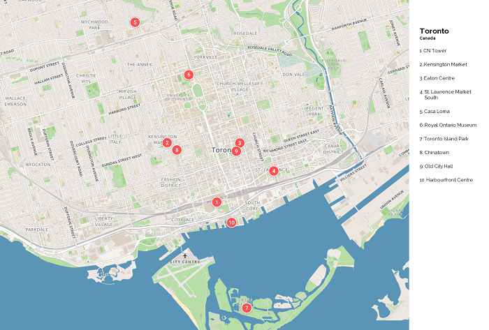
There are lots of interesting sights to see in Toronto. Aside from the iconic CN Tower, you should also make sure to visit the Casa Loma, Royal Ontario Museum, and the Ripley’s Aquarium of Canada. To make the most of your holiday in Toronto, use our free printable copy of the Toronto Tourist Sightseeing Map as your guide.
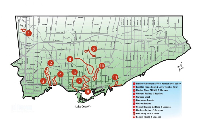
Despite the modern infrastructures and development, Toronto is still filled with tons of green spaces. If you prefer to explore by foot and wander around the parks and gardens in the city, go check out our Toronto Walking Tour Maps. This map will give you information on which places in Toronto can be possibly explored on foot.
For families who are taking their kids with them on their holiday to Toronto, the most convenient way to explore this lovely city is to join the Hop on Hop off Bus Tours. If you want to know where these tours will take you, our Toronto Hop On Hop Off Bus Map will guide you.
Read More See Less