Philadelphia Tourist Attractions Maps | City Tours Map
Your Complete Guide to the Philadelphia Tourist Attractions Map
Philadelphia is a historic and culturally rich city, known for its founding role in American history, world class museums, picturesque neighborhoods and vibrant public squares. With major landmarks spread across Old City, Center City, the Parkway Museums District, Penns Landing, University City and South Philadelphia, a clear tourist attractions map is essential for planning your visit. This guide highlights the most important Philadelphia tourist attractions, helping you explore historic sites, museums, parks and cultural districts with ease.
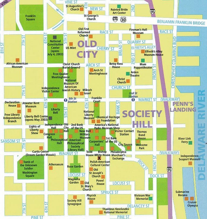
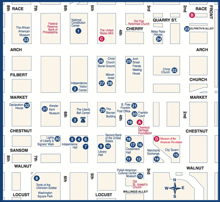
The attractions map marks Philadelphia’s most iconic historic landmarks including the Liberty Bell, Independence Hall, Independence National Historical Park, Congress Hall and Carpenters Hall. These sites define the city’s revolutionary past, and the map helps visitors understand the layout of Old City, where many of these important buildings sit within short walking distance from each other.
Philadelphia’s renowned museums and cultural institutions are also featured on the map, such as the Philadelphia Museum of Art, Rodin Museum, Franklin Institute, Museum of the American Revolution and the Barnes Foundation. Located along the Benjamin Franklin Parkway and throughout the city, these institutions offer art, science and historical exhibits that appeal to all ages. The map helps travelers group nearby museums to plan efficient and interesting sightseeing days.
Popular green spaces and outdoor attractions are clearly shown, including Fairmount Park, Rittenhouse Square, Spruce Street Harbor Park, Race Street Pier and Schuylkill River Trail. These areas provide scenic walking routes, riverfront views, gardens and family friendly spaces. The attractions map highlights entrances and pathways, making it easy to explore Philadelphia’s outdoor settings.
Neighborhoods known for culture, food and historic charm like South Street, Fishtown, Northern Liberties, Manayunk and Chinatown are included as well. With diverse dining, boutique shopping, music venues and artistic corners, the map helps visitors identify the best routes through these lively districts.
The map also showcases major modern attractions such as the One Liberty Observation Deck, Reading Terminal Market, Penns Landing waterfront, Kimmel Center and City Hall. With attractions located across multiple neighborhoods, the map gives travelers a clear idea of distances, transport connections and ideal sightseeing routes.
Travelers looking for Philadelphia attraction tickets will find the map invaluable for identifying entrances, visitor centers and ticket booths at locations like the Museum of the American Revolution, Independence Hall and the Philadelphia Museum of Art.
Whether you want to explore historic monuments, stroll through parks, enjoy cultural exhibitions or discover local neighborhoods, the Philadelphia Tourist Attractions Map provides a complete overview of the city’s top places to visit. It helps you organize sightseeing days, group nearby attractions and experience Philadelphia at your own pace.
Scroll down to view the full attractions map and begin planning your Philadelphia journey through history, art, culture and scenic urban spaces.
Frequently Asked Questions About Philadelphia Tourist Attractions
1. What are the top tourist attractions in Philadelphia?
Key attractions include the Liberty Bell, Independence Hall, Philadelphia Museum of Art, Reading Terminal Market and the Benjamin Franklin Parkway museums.
2. How does the Philadelphia tourist attractions map help visitors?
The map shows where major historic sites, museums, parks and neighborhoods are located, helping visitors plan efficient sightseeing routes.
3. Are Philadelphia attractions walkable?
Many central attractions in Old City and Center City are walkable. The map indicates subway and bus connections for longer distances.
4. Do Philadelphia attractions require tickets?
Attractions such as museums, historic buildings and observation decks require tickets. The map highlights entrances and ticket points.
5. What is the best area for sightseeing in Philadelphia?
Old City is ideal for history, the Parkway for museums and Penns Landing for waterfront views. The map outlines each district clearly.
6. How can I plan one day of sightseeing in Philadelphia?
A common route includes Independence Hall, the Liberty Bell, Franklin Institute and Rittenhouse Square. The map helps visitors organize these stops efficiently.
Top Philadelphia Attractions Skip-the-line Tickets & Tours
Philadelphia is one of the most populous cities in the US. Famously called “Philly”, the city plays a major role in the country’s colorful history. When exploring Philadelphia, you’ll come across several colonial sights, beautiful architectures, and some world-class galleries and museums.
The best way to get around Philadelphia is by using its modern transportation system. With the help of the Philadelphia metro map, you would be able to explore the city without having to spend a lot of money. If you need help in taking the buses and trains in the city, the Philadelphia Transport Map will surely be a big help. So get our free printable copy of this map and make sure you bring it with you on your trip to Philadelphia.
For visitors who wanted to see Philadelphia’s famous sights and attractions, the Philadelphia Tourist Sightseeing Map is the right map for you. This map includes details on how you can visit the city’s popular attractions including the Eastern State Penitentiary, Edgar Allan Poe National Historic Site, Philadelphia zoo, and other famous sites in the city.
For those who would rather walk as they explore the city’s best attractions, the Philadelphia Walking Tour Maps are a big help. These maps will provide information on how to explore the city on foot, from visiting Philadelphia’s public arts and museums to heading to the city’s markets and town squares.
If you don’t want to walk or take the public transportation, the best option is to take the Hop on Hop off Bus tours. This is the most comfortable way of seeing the city since you’ll be riding in an air-conditioned bus. So if you’re taking your kids with you on your trip, you better refer to our free printable copy of the PhiladelphiaHop on Hop off Bus map to find out where the buses would stop.
Read More See Less