Sydney Tourist Attractions Maps | City Tours Map
Your Complete Guide to the Sydney Tourist Attractions Map
Sydney is a vibrant harbour city known for its world famous skyline, sandy beaches, cultural landmarks and scenic coastal walks. With major attractions spread across Circular Quay, The Rocks, Darling Harbour, Bondi Beach, Manly, Barangaroo, Hyde Park and the Royal Botanic Garden, a detailed tourist attractions map is essential for planning your sightseeing. This guide highlights the most important Sydney tourist attractions, helping you explore waterfront icons, museums, beaches, gardens and cultural districts with ease.
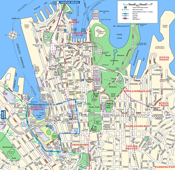
The attractions map features Sydney’s most iconic sights including the Sydney Opera House, Harbour Bridge, Circular Quay, The Rocks, Darling Harbour and Barangaroo Reserve. These famous landmarks sit around Sydney Harbour, and the map helps visitors understand ferry routes, walking paths, viewpoints and public transport links connecting these must see locations.
Sydney’s outdoor and coastal attractions are also clearly displayed, such as Bondi Beach, Bondi to Coogee Walk, Manly Beach, Wattamolla, Royal National Park and the scenic Cremorne Point Walk. These areas provide ocean views, cliffside trails, beaches and natural escapes. The attractions map helps visitors locate coastal routes, beach access points and ferry terminals.
Cultural attractions and museums are highlighted across the map, including the Art Gallery of New South Wales, Australian Museum, Museum of Sydney, Powerhouse Museum, Hyde Park Barracks and State Library of NSW. With museums positioned across the central districts, the map helps visitors group nearby cultural sites for efficient sightseeing days.
Beautiful outdoor spaces and gardens such as the Royal Botanic Garden, Mrs Macquaries Chair, Hyde Park, Centennial Parklands and Barangaroo Reserve are shown throughout the map. These green areas offer iconic harbour views, walking tracks and picnic spots, and the map highlights entrances, pathways and scenic viewpoints.
Popular neighborhoods known for dining, markets and local culture including Surry Hills, Newtown, Pyrmont, Chippendale and Paddington also feature on the attractions map. These districts reflect Sydney’s creative and multicultural side, offering boutique shops, galleries, street murals and vibrant food precincts.
Travelers searching for Sydney attraction tickets will find the map useful for identifying ticket counters, entrances and transport access points for attractions such as the Sydney Opera House, harbour cruises, wildlife parks, museums and observation decks like the Sydney Tower Eye.
Whether you plan to explore the harbourfront, wander through historic laneways, relax on golden beaches, enjoy museums or discover scenic coastal walks, the Sydney Tourist Attractions Map provides a complete overview of the city’s best places to visit. It helps you plan routes, group nearby attractions and experience Sydney at your own pace.
Scroll down to explore the full attractions map and begin planning your Sydney journey through beaches, harbour views, cultural icons and natural beauty.
Frequently Asked Questions About Sydney Tourist Attractions
1. What are the top tourist attractions in Sydney?
Key attractions include the Sydney Opera House, Harbour Bridge, Darling Harbour, Bondi Beach, The Rocks and Royal Botanic Garden.
2. How does the Sydney tourist attractions map help visitors?
The map shows landmarks, beaches, museums and transport connections, helping visitors plan efficient routes across the city.
3. Are Sydney attractions walkable?
Many attractions in the harbour area are walkable, and the map highlights walking paths, coastal trails and ferry points.
4. Do Sydney attractions require tickets?
Some attractions such as the Sydney Tower Eye, harbour cruises and museums require tickets. The map identifies entrances and ticket counters.
5. What is the best area for sightseeing in Sydney?
Circular Quay is ideal for harbour icons, Bondi for beaches, and Darling Harbour for family attractions. The map outlines each area clearly.
6. How can I plan one day of sightseeing in Sydney?
A popular route includes the Opera House, Harbour Bridge walk, The Rocks, Darling Harbour and a sunset at Bondi Beach. The map helps organise these stops smoothly.
Top Sydney Attractions Skip-the-line Tickets & Tours
Australia Multi-City Attractions Pass
The Ultimate Sydney Attractions Pass
Sydney Attractions Pass: SEA LIFE Aquarium, Sydney Tower Eye, WILD LIFE Zoo and Madame Tussauds
Madame Tussauds Sydney Entrance Ticket
Go City | Sydney Explorer Pass with 25+ Attractions and Tours
Vivid Dinner Cruise Sydney Harbour
Ultimate Sydney Pass
Sydney Harbour Tall Ship Twilight Dinner Cruise
As the biggest city of Australia, there are just so many things to see and do in Sydney. If you're visiting for the first time, the vastness of the city might overwhelm you and this is why you might find it necessary to grab a copy of the Sydney tour map. Having a copy of the map of Sydney means you’ll be able to explore various tourist destinations without getting lost in the busy streets of Sydney.
So to help first time visitors to navigate their way in Sydney, Tripindicator has provided a Sydney interactive map that you can access on your phone anytime. It’s not only free, but it’s easy to use as well. If you’re going to see the top attractions of Sydney, such as the Sydney Opera House, the Harbour Bridge, Darling Harbour, Bondi Beach, and more, this map will provide you with directions on how to get to these places.
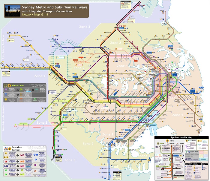
Taking the Sydney Metro is a great way to navigate Sydney and explore the famous sites and attractions. When it comes to this, you need to get a copy of the Sydney metro map with attractions. That way, you will know which train to take and in what station you should get off.
Each year, millions of tourists from around the world would come to Sydney. Thus, the city can sometimes get busy. But with the help of the Sydney tourist map printable, you should be able to navigate the city with ease. Whether you are visiting the beautiful white sandy beaches or checking out the best restaurants in the city, the will surely come in handy.
For those who prefer to explore Sydney on foot, the Sydney tourist map walking is highly recommended. These Sydney city sightseeing maps will help you find your way around the city’s famous attractions, whether you are walking or taking the public transportation.
The printable map of Sydney features the top museums, art galleries, as well as famous landmarks and attractions in Sydney. So if you’re visiting for the first time and you have no idea where to go, this map is very helpful. The tourist information Sydney map is so easy to use and includes detailed instructions on the best way to get to a particular place in Sydney.
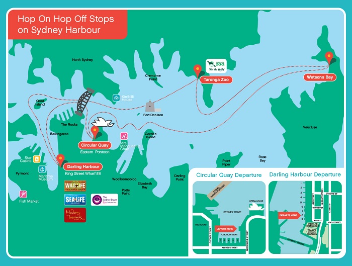
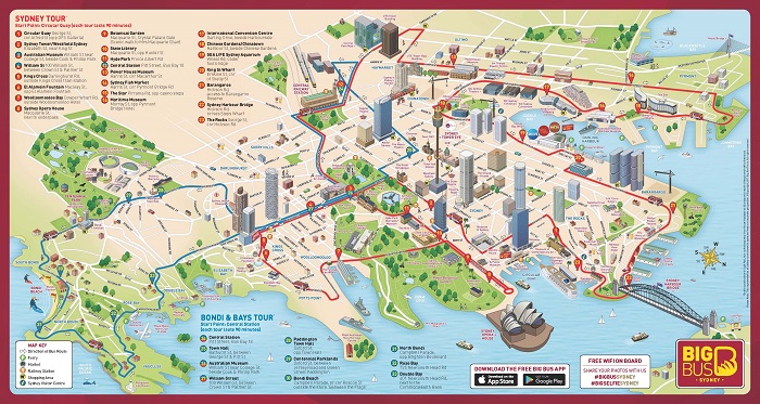
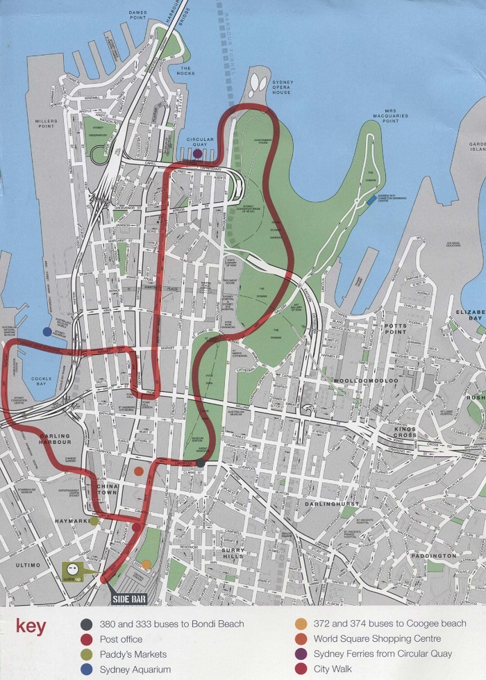
Taking the hop on hop off bus in Sydney is another convenient way of exploring the city. If you want to know where the bus will take you, then check out the Sydney hop on hop off bus map.
Read More See Less